About the Author: Karla Fetrow is an experienced off-road driver tackling some of the toughest terrain in the U.S in Alaska on a daily basis. Having been raised in the remote areas of Alaska, it is common knowledge to the rural inhabitant that there are places you just can’t go without a Jeep, Jeep Wrangler or other sturdy off-road vehicle. Karla frequently writes on behalf of Extreme Terrain.

Alaskan Demographics
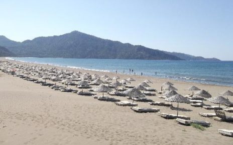
The size of Alaska is staggering for any mind accustomed to driving from one state to another, or covering several states in a day. Its boundaries cover over 586,000 square miles. If you cut Alaska in half, Texas would be the third largest state. Although it receives over a million visitors a year, the only traffic congestion you’ll find is in the summer, between Anchorage and Homer, on the Kenai Peninsula, when fishing season begins and ends. It’s nearly all untouched wilderness. Over half of the population of Alaska lives in the Anchorage Bowl or the Matanuska Valley. If you divided the land mass in equal parts per citizen, there would be one person for every five miles.
There are three primary regions used loosely to indicate location; southeastern, south central and the interior. These regions have their own distinct climate. Southeastern Alaska is coastal, thick with islands and comprises the rain belt. The weather is mild, with 60-70 degree temperatures in the summer and an average temperature of 32 degrees in the winter. South central Alaska is generally somewhat warmer in the summer, has less rain, but can often drop down to below zero temperatures in the winter. Interior Alaska is semi-arid. Its summer temperatures can get very hot; over eighty degrees Fahrenheit, which might not sound like much, but the sun never sets during those languid months, leaving you with a somewhat baked feeling. Winters are extremely cold; often dropping to -30 and staying there for weeks at a time.
Because Alaska is nearly all wildernesses, the best way to receive an overall view is to visit it by region. However, if you are driving, prepare yourself for an all-summer stay. Just crossing Canada will take six days if you stop to rest for the evenings. Each region covers an area of several hundred miles by road with high mountain passes, deep gorges, numerous rivers and varying degrees of road difficulty. All the main roads are paved, but all contain numerous off roads to old mining camps or fishing and hunting spots. Camping areas are available a short distance off all the main roads.
The Stewart Cassiar Highway 37
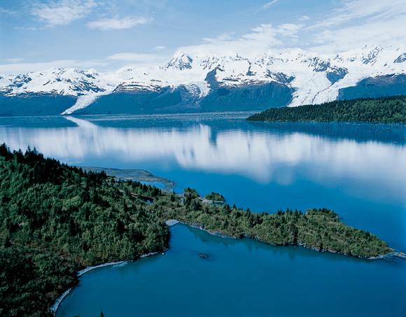
While the Alcan is the most direct route to Alaska, if you are a West Coast driver or want a true view of Alaska’s southeast region, plan your trip around the Stewart Cassiar Highway. A combination of old logging and mining roads, your trip will take you through the rain forest and a chance to see several charming, very small towns, including Stewart B.C., Hyder, and Skagway. The four hundred fifty mile long journey meanders through the coastal range, giving you the chance to see numerous glaciers, magnificent waterfalls and a vast variety of wildlife. Parts of the road are still under construction, and many areas are prone to landslides. Stock up well on groceries and fill your vehicle with gas at every opportunity as the settlements are few and far apart.
If you would like to do some whale watching, hop on a ferry at Skagway, Haines or Valdez, with a destination for Whittier. Hump back whales, Orcas (killer whales), gray whales and Minke whales are all prevalent in Southeast Alaska, and can sometimes be seen from shore.
Whittier is a very small town, but it is the most important deep water port in mainland Alaska. Its rain season can be ferocious. The locals list four kinds of rain; drizzling rain, downpours, sleet with rain and sideways rain. Whatever type of rain they’re having, however, they don’t worry about it. The docks, businesses, schools and single large condominium, where half the town lives, are all connected by pedestrian tunnels.
Driving is limited in Whittier, even with four wheel drive, as the town perches on a mountain that plunges straight into an ocean. However, it has some of the best deep water fishing around. Bring along a canoe or kayak and paddle along the shore or to one of the nearby small islands for that prize halibut, salmon or cod.
Talkeetna; Blast from the Past
Leaving Whittier also requires going through a tunnel. At a little over four miles long, it is the second longest vehicle transportation tunnel in the United States. It burrows straight through a mountain and comes out at Portage Glacier. Portage Glacier is a very popular tourist attraction. As the glacier moves, it calves into a lake. You’ll be able to see floating icebergs even if you did take a mainland cruise. A special note about glaciers. They make their own weather. Even if the day is warm and sunny, it can be chilly and overcast within the vicinity of one of them.
Once you are back out on the main highway, it’s just a forty minute drive to Anchorage. It’s a good place to get back in touch with civilization, refresh yourself, and remember all the reasons you wanted to escape into the wilderness in the first place. Those reasons become a driving force when Talkeetna becomes your next goal.
Talkeetna is at the south central edge, with a climate bordering on interior temperature ranges. This gold mining, trapping and fishing town is one of the oldest in Alaska, with many of the original buildings still standing. While it receives some tourism, it’s most noted as the last stop off point for climbing Mt. McKinley; or in Alaskan language; Denali.
The people of Talkeetna are very friendly and wildly humorous. An ordinance was passed against getting the horses drunk after one began making nightly visits to a local tavern for a pitcher of beer. Each October, they hold a bachelor auction, renting out bachelors for an evening of fun for competing women who drive in from as far away as Anchorage for the privilege of spending a day with a Talkeetna man.
Their colorful history includes the bragging rights of the town that poisoned President Harding. Whether the story is true or not, Harding died in San Francisco, just a few days after leaving Talkeetna, where he attended the opening ceremony of what was then, the brand new Alaskan Railroad.
Driving to Talkeetna means numerous views of Denali, which is first visible twenty miles outside of Anchorage, in the town of Chugiak. In Talkeetna, the view becomes spectacular and the Big One actually reveals itself with more clarity than in most locations within the Denali National Park.
End of the Road
Your trip wouldn’t be complete without reaching the official end to the Alaskan road system in Circle, a little over a hundred miles north of Fairbanks. Although you’ve left mountain and glacier country by the time you’ve reached Circle, it is the best place to see the mighty Yukon River. Also, along the way, you might wish to visit one of the various hot springs. The most popular one is Chena, which will take you a little out of your way as it’s on the Elliot Highway. However, the area around Circle contains numerous hot springs, many of which are undeveloped. Check with the Alaska Public Lands Information Center and they will give you a map of the off road locations where you can go on that wilderness adventure of your life, scrape the mud off your boots, and enjoy a wonderful, healthy soak in a secluded hot spring.